

Nephin Beg [Neifinn Bheag]
Good walks are even better shared.
F9310 : Summit of Nephin Beg - view towards Slieve Carr
Colin Park Photo source
Overview
Nephin Beg [Neifinn Bheag]
Nephin Beg, or Neifinn Bheag in Irish, stands proudly at 806 meters above sea level within the Nephin Beg Range in County Mayo. While it may not be the tallest mountain in Ireland, it's a perfect gem for those in search of breathtaking views and a pleasant trekking experience.
Geology
This majestic peak is primarily composed of slate, adding to its rugged charm. The unique rock formations are a testament to the area's glacial history, creating a stunning landscape both underneath your feet and as far as the eye can see.
Route Information
One of the most popular routes to take is the Nephin Beg Loop Trail. Covering approximately 10.5 km, this moderate trail winds through lush terrain, providing excellent viewpoints along the way. It's an ideal trek for families and those looking to enjoy the great outdoors without too much strain.
Summit Features
Upon reaching the summit, expect to find a prominent stone cairn. It’s not a fancy hotel, but hey, it’s got the best views in town! Keep your eyes peeled for the majestic ravens that might come to inspect your snacks.
Terrain
The terrain offers a delightful mix of rocky and grassy patches, with a splash of bogginess. Wellingtons could be your best friend here; after all, no one likes soggy socks!
Views
From the top, the panorama is simply glorious. You’ll be treated to sweeping vistas of the Atlantic Ocean, the Ox Mountains, and the surrounding wilderness. The best seasons for these views are spring and summer when the flora is in full bloom. But if autumn is your jam, don’t miss the vibrant colours.
Hazards
While trekking, keep your wits about you. Wet and slippery stones can pose a hazard, especially after a rain shower—never underestimate the Irish weather! Be prepared for the fog; it loves to play hide and seek!
Access
To kick off your journey, there’s a handy lay-by for parking near the trailhead located off the R315—just avoid blocking the gates!
For those relying on public transport, you can catch a bus from Castlebar to the village of Lough Feeley, then grab a taxi to the trailhead.
Facilities
Castlebar, which lies about 20 km away, is your nearest town and has public toilets and local cafes where you can refuel post-hike with a nice cuppa.
History
The name Nephin means 'little Nephin', a nod to its stature compared to nearby giants. The region is steeped in folklore, with stories of ancient battles that add a pinch of magic to your hike.
So, lace up those boots and get ready for an unforgettable adventure at Nephin Beg!
Explore routes near Nephin Beg [Neifinn Bheag]
Walks starting near this hill. Open a route to check its map, distance and full itinerary.
Route planning notes
These notes describe possible approaches. Check a route's map and access information when planning your walk.
Nephin Beg Loop Trail
A scenic loop that affords stunning views, the trail meanders through varied terrain, with moderate inclines and a stroll through lush countryside.
Make a day of it, together
Find someone to share the walk with, or organise a day out along a route you like.
Photo Gallery
View all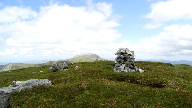 Photo could not load
F9310 : Summit of Nephin Beg - view towards Slieve Carr
Colin Park
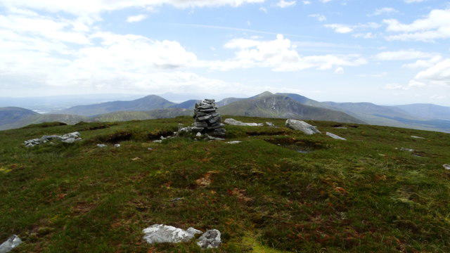 Photo could not load
F9310 : Summit of Nephin Beg - view towards Glennamong
Colin Park
Hill facts and local notes
Classifications
Elevation
627m
2,057 ft
Prominence
364m
Coordinates
54.0302, -9.6306
F931102
OS Map
23
At the Summit
At the summit, hikers can find a well-constructed stone cairn and a breathtaking panoramic view of Nephin Mountain and the surrounding countryside. Keep an eye out for the occasional curious raven!
Terrain & Geology
Nephin Beg is primarily composed of slate, which gives way to the dramatic rugged appearance of the peak. The rock formations present are indicative of the area's glacial history, leading to its unique topography.
Views & Scenery
From the summit, enjoy dramatic views of the Atlantic Ocean, the Ox Mountains, and the sprawling Nephin Beg range, all beautifully framed by the rugged Irish landscape.
History & Heritage
Name Origin
The name 'Nephin' comes from the Irish 'Neifinn', meaning 'little Nephin', reflecting its stature compared to its taller neighbours.
Historical Significance
Historically, the area around Nephin Beg has been rich in Irish folklore, with tales of ancient battles and mythological figures that add a layer of intrigue to your adventure.
Getting There & Facilities
Parking
There is a small lay-by near the trailhead off the R315, suitable for a few cars. Be sure not to block any gates!
Public Transport
Buses run from Castlebar to the nearby village of Lough Feeley, from where you can catch a taxi to the trailhead.
Nearby Facilities
There are public toilets located in Castlebar, and a few local cafes serve a decent cup of tea - a perfect reward after your hike!
Safety Information
Known Hazards
- Be mindful of wet and slippery rocks, especially after rain. Fog can roll in quickly, reducing visibility, so keep an eye on the weather.
General Safety Tips
- Check weather conditions before setting out
- Carry appropriate clothing and equipment
- Let someone know your planned route
- Take a map, compass, and GPS device
- Carry emergency supplies: food, water, first aid kit, torch
Hills
Some common questions about the hills answered
Are there group walks up Nephin Beg [Neifinn Bheag]?
Many walkers use Walkmates to join or organise walks with others. You can check for group walks around Nephin Beg [Neifinn Bheag] through the maps
Are there other walkers around Nephin Beg [Neifinn Bheag]?
Activity varies by location and time, but Walkmates lets you see whether others have shared walks or shown interest in this area. Find other people through the walking friends search walking friends for Nephin Beg [Neifinn Bheag] search or of course create your own walk for Nephin Beg [Neifinn Bheag]
Can I organise a walk to Nephin Beg [Neifinn Bheag]?
Yes. If there aren’t any walks listed already, you can create a walk and make it available for others to join.
If you're signed up to Walkmates, you can create a walk to Nephin Beg [Neifinn Bheag].
How do I find a walk up this hill?
There are often multiple ways to walk this hill, depending on experience and route preference. Walkmates helps you explore walks and routes that others have shared.
Can I suggest a new route up Nephin Beg [Neifinn Bheag]?
Yes. You can suggest or create routes to share with others. Walkmates focuses on the social side of walking, so routes are used to help people organise walks and explore areas together, rather than as detailed navigation tools or route libraries.
Other uses really appreciate knowledgeable walkers sharing their routes. Share your favourite route to Nephin Beg [Neifinn Bheag] here
The is an error or something incorrect about this hill. How do I let you know?
We always strive to keep the information on Walkmates as accurate as possible. If you find an error, please let us know through the contact form and we'll aim to correct it as quickly as possible
Community Discussion
Comments
Location
![Nephin Beg [Neifinn Bheag] location map](https://cdn.walkmates.com/hill-maps/hill-sources/20197/54.03020_-9.63064.png)
Grid reference: F931102
View on OpenStreetMapOpens a map in a new tab, centred on the hill.
No comments yet. Be the first.